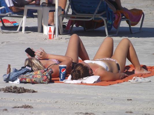
 Headline Surfer photo by Henry Frederick / Just a couple of weeks ago, it was bikini weather on the hard sands of Daytona as shown in this scene-setter. Now? sweat pants and sweaters.
DAYTONA BEACH -- Enjoy the seasonably-warm temperatures near 80 today and Tuesday because by mid-week, it's going to be a lot colder at the World's Most Famous Beach with temps dropping to the low 70s.
Oh, and it might rain, too. "Might" is the operative word as in 20 percent chance of precipitation. You can be guaranteed it won't be snow, though. That much is certain about the weather here in Central Florida.
Oh, and it might rain, too. "Might" is the operative word as in 20 percent chance of precipitation. You can be guaranteed it won't be snow, though. That much is certain about the weather here in Central Florida.
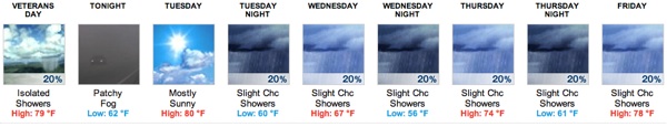
For Greater Daytona Beach, Lake Mary and Palm Coast, the National Weather Service in Melbourne is calling for a slight chance of isolated showers after sunrise sunrise on this Veteran's Day, otherwise it's mostly sunny, with a high near 79, and a northeast wind of 5 to 10 mph.
Tonight will have patchy fog after 11 p.m. Otherwise, mostly cloudy, with a low around 62. North northeast wind around 5 mph becoming calm.
For the rest of the week:
Tuesday: Mostly sunny, with a high near 80. Light northwest wind becoming north 5 to 10 mph in the morning.
Night: A 20 percent chance of showers. Mostly cloudy, with a low around 60. Windy, with a north wind 5 to 10 mph increasing to 15 to 20 mph after midnight. Winds could gust as high as 30 mph.
Wednesday: Night A 20 percent chance of showers. Mostly cloudy, with a low around 56. Windy, with a north northeast wind 15 to 20 mph, with gusts as high as 30 mph. Night: A 20 percent chance of showers. Partly sunny, with a high near 67. Windy, with a north northeast wind around 25 mph, with gusts as high as 35 mph.
Thursday A 20 percent chance of showers. Partly sunny, with a high near 74. East northeast wind around 15 mph, with gusts as high as 25 mph. Night: A 20 percent chance of showers. Mostly cloudy, with a low around 61. East wind 10 to 15 mph.
Friday: A 20 percent chance of showers. Partly sunny, with a high near 78. East wind around 10 mph. Night: A 30 percent chance of showers. Mostly cloudy, with a low around 66. East wind around 10 mph.
Weekend: Mostly sunny, with a high near 79 on Saturday and similar conditions on Sunday with a high of 81.
FAST FACTS: Why snow in Sunshine State is so rare
This vintage photo from February 1889 on the steps of the Florida Capitol showed there was enough snow for a snowball fight.
It is rare for snow to fall in Florida because freezing temperatures are generally caused by the cold and dry winds of anticyclones. Frost is more common than snow, requiring temperatures of 45 °F (7 °C) or less at 2 m (7 ft) above sea level, a cloudless sky, and a relative humidity of 65% or more.
In the general case, for snow to occur, the polar jet stream must move southward through Texas and into the Gulf of Mexico, with a stalled cold front across the southern portion of the state curving northeastward to combine freezing air into the frontal clouds. While light snowfall occurs every few years across the northern panhandle and the north central peninsula, most of Florida is in a rare portion of the continental U.S. that receives a mean maximum monthly snowfall amount of zero, the only other such areas being southern Texas and parts of California.
Did You Know?
-- On Feb. 2, 1951, snowfall began and ended the following day, with 2 inches (51 mm) accumulated at St. Augustine in St. Johns County and Crescent City in Putnam County, just north of Pierson in Volusia County.
-- The last reported sighting of "light" snow flurries in the Daytona Beach area occurred on Jan. 3, 2008. Source: Wikipedia


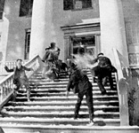 Photo credited to floridamemory.com / Wikipedia / Headline Surfer® /