

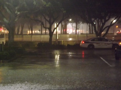
 Headline Surfer® photo by Henry Frederick /
 A Port Orange cop car is shown at 6:30 p.m. near the intersectioon of Nova Road and Spruce Creek Boulevard in Port Orange as a rainstorm pelted the area.
DAYTONA BEACH -- Heavy rain pelted Central Florida with wing gusts reported as high as 50 mph plus lightning strikes, from Kissimmee in Osceola County and heading to the coastal communities.
The storm started during the evvening commute over Central Florida moving eastward over Orange, Lake and Marion counties and into Brevard, Volusia, Flagler, Putnam and St. Johns Counties just before 7 p.m.
Here is the weather forecast for the Daytona Beach-area from the National Weather Service in Melbourne:
Tonight: Showers and possibly a thunderstorm before 1 a.m., then a chance of showers. Some storms could be severe, with damaging winds and frequent lightning. Low around 57. Southwest wind 10 to 15 mph, with gusts as high as 25 mph. Chance of precipitation is 100%.
Thursday: Cloudy through mid-morning, then gradual clearing, with a temperature falling to around 57 by 10 a.m. Windy, with a west wind 15 to 25 mph, with gusts as high as 35 mph.
Thursday Night: Mostly clear, with a low around 40. West wind 5 to 10 mph. Friday Sunny, with a high near 68. Light west wind becoming west southwest 5 to 10 mph in the morning.
Friday Night: Mostly clear, with a low around 53. South southwest wind 5 to 10 mph.
Saturday: Sunny, with a high near 69. West southwest wind 5 to 10 mph becoming north in the afternoon.
Saturday Night: Mostly clear, with a low around 48. North northeast wind around 5 mph becoming calm in the evening.
Sunday: Sunny, with a high near 72. Calm wind becoming north around 5 mph in the afternoon.