
DAYTONA BEACH, Fla. -- With Hurricane Irma slowly moving through the Carribean on its way to Florida with sustained winds of 145, Sunshine State residents are feeling anxious.
"Apparently, I'm wide awake on hurricane adrenaline," Kahlin Grant of Daytona Beach wrote on her Facebook page at 4:20 this morning. "It's similar to Christmas morning excitement, but way less magical."
Francesca Caviasca told Grant, she, too, was wide awake, "but going to go to bed now."
Grant responded, I was planning on getting up in an hour and a half anyway for work so might as well just 'hunker down' and ride it out at this point."
Hunker down and ride it out as in Grant's anxiety. She told her friends, "I think the not knowing is what is giving me anxiety. I like having a plan. If Irma could just provide a schedule of events that would be great."
But unfortunately, it's up to the weather experts to figure that out, and so far they really haven't."
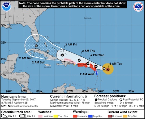
Here is the latest update from the National Hurricane Center: Hurricane Irma has strengthened into a dangerous Category 5 hurricane as it bears down on the Leeward Islands, and will rake through the Virgin Islands, Puerto Rico, Hispañola, the Bahamas and Cuba before posing a serious threat to Florida and parts of the Southeast beginning this weekend.
The center of Irma is located just under 300 miles east of the Leeward Islands and is moving westward at about 15 mph. Irma's maximum sustained winds have increased to 175 mph based on data from NOAA and Air Force Hurricane Hunter aircraft.
Based on wind speed, Irma is the strongest Atlantic hurricane since Felix and Dean in 2007, which also had maximum sustained winds of 175 mph.
Here is the latest update from the National Hurricane Center:
Hurricane Irma has strengthened into a dangerous Category 5 hurricane as it bears down on the Leeward Islands, and will rake through the Virgin Islands, Puerto Rico, Hispañola, the Bahamas and Cuba before posing a serious threat to Florida and parts of the Southeast beginning this weekend.
The center of Irma is located just under 300 miles east of the Leeward Islands and is moving westward at about 15 mph. Irma's maximum sustained winds have increased to 175 mph based on data from NOAA and Air Force Hurricane Hunter aircraft.
Based on wind speed, Irma is the strongest Atlantic hurricane since Felix and Dean in 2007, which also had maximum sustained winds of 175 mph.
Additionally, Irma is just the 17th Atlantic hurricane to have maximum sustained winds of 175 mph or greater, according to Dr. Phil Klotzbach, a tropical scientist at Colorado State University, the Weather Channel said.
Gov. Rick Scott has declared a state of emergency in Florida, saying: “Hurricane Irma is a major and life-threatening storm and Florida must be prepared.
“I have continued to be briefed by the Florida Division of Emergency Management on Hurricane Irma and current forecast models have Florida in Irma's path - potentially impacting millions of Floridians."
Scott said President Donald Trump has “offered the full resources of the federal government as Floridians prepare for Hurricane Irma."
While it is still too soon to narrow down specifics on the exact path of Irma's center and eyewall, there is an increasing chance of a major hurricane strike on at least part of South Florida, including the Florida Keys, this weekend.
As mentioned before, the vast majority of the forecast guidance indicates Irma will begin to turn more to the north sometime this weekend.
The strength and expansiveness of the Bermuda-Azores high over the Atlantic Ocean and the timing, depth and location of a southward dip in the jet stream near the eastern U.S. will dictate where and when that northward turn occurs.
According to the latest National Hurricane Center forecast, the center of Irma may be very close to South Florida by Saturday night, with conditions going downhill already during the day, Saturday.
However, as the NHC reminds weather forecasters, average errors in the track of the center of an Atlantic tropical cyclone 4 to 5 days out are between 175 and 225 miles, which can make a large difference in impacts.
For now, all residents along the Southeast coast and eastern Gulf Coast, including Florida, Georgia and the Carolinas, should monitor the progress of Irma closely. In addition, Irma's wind field will be large, therefore, dangerous surf and coastal flooding will likely exist throughout the southeastern U.S. coastline even well away from Irma's center by late week.
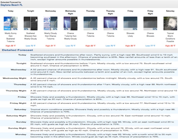 Here is the extended forecast for Daytona Beach, FL from the National Weather Service in Melbourne.