

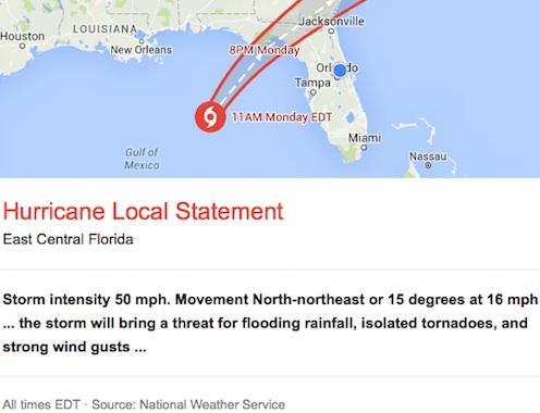
 DAYTONA BEACH, Fla. -- A Tropical Storm Warning remains in effect for inland and coastal areas of Volusia County, Orange, Seminole,Brevard and Lake counties, according to the NationalWeather Service in Melbourne, which is tracking TS Colin located about 360 miles west-southwest of Orlando with 50 mph winds and moving north-northeast at 16 mph.
Latest on the storm's path
Colin continues to move northward over the eastern Gulf of Mexico. The storm is expected to approach the Big Bend coastline this evening before passing to the north of the area overnight tonight and emerging into the Atlantic Ocean early Tuesday morning.
Despite the center of Colin remaining well to the north and west, the storm will bring a threat for flooding rainfall, isolated tornadoes, and strong wind gusts into tonight. Fast-moving squalls will increase in coverage this afternoon with a higher coverage of heavy rain expected tonight as the system passes by to our North. Occasional gusts to tropical storm force are likely within the fast-moving squalls, especially from Cape Canaveral to Kissimmee and points north.
Total rainfall accumulations between 2 and 4 inches are expected with locally higher amounts possible. A Flood Watch remains in effect through tonight.
Potential impacts
Wind: Protect Against hazardous wind having possible limited impacts across East Central Florida.
Potential impacts include: Damage to porches, awnings, carports, sheds, and Unanchored mobile homes. Unsecured lightweight objects blown about. Many large tree limbs broken off. A few trees snapped or uprooted, but with greater numbers in places where trees are shallow rooted. Some fences and roadway signs blown over. A few roads impassable from debris, particularly within urban or heavily wooded places. Hazardous driving conditions on bridges and other elevated roadways. Scattered power and communications outages.
Flooding rain: Protect Against locally hazardous rainfall flooding having possible limited impacts across East Central Florida.
Potential impacts include: Localized rainfall flooding may prompt a few evacuations. Rivers and tributaries may quickly rise with swifter currents. Small streams, creeks, canals, and ditches may become swollen and overflow in spots. Flood waters can enter a few structures, especially in usually vulnerable spots. A few places where rapid ponding of water occurs at underpasses, Low-lying spots, and poor drainage areas. Several storm drains and retention ponds become Near-full and begin to overflow. Some brief road and bridge closures.
Tornadoes: protect against a dangerous tornado event having possible significant impacts across Central Florida.
Potential impacts include: The occurrence of scattered tornadoes can hinder the execution of emergency plans during Tropical Events. Several places may experience tornado damage with a few locations seeing considerable damage, power loss, and communications failures. Locations could realize roofs torn off frame houses, mobile homes demolished, boxcars overturned, large trees snapped or uprooted, vehicles tumbled, and small boats tossed about. Dangerous projectiles can add to the toll. Protect Against a tornado event having possible limited impacts across Central Florida.
Precautionary/preparedness actions
Now is the time to complete all preparations to protect property in accordance with your emergency plan. Outside preparations should be wrapped up as soon as possible before weather conditions deteriorate. Any remaining evacuations and relocations should be completed before the onset of tropical storm force winds.
• Keep cell phones well charged and handy. Also, Cell Phone Chargers for automobiles can be helpful after the storm. Locate Your Chargers and keep them with your cell phone.
• In Emergencies it is best to remain calm. Stay informed and focused on the situation at hand. Exercise patience with those you encounter.
• Be a Good Samaritan and helpful to others. If you are a visitor, listen for the name of the city or town in which you are staying during local news updates.
• Be sure you know the name of the county you are located in, temporarily or permanently.
• Pay attention for instructions from local authorities. Closely monitor NOAA weather radio or other local news outlets for official storm information. Be ready to adapt to possible changes to the forecast.
Additional sources of info
For information on appropriate preparations See ready.gov. For information on creating an emergency plan see getagameplan.org. For additional disaster preparedness information see redcross.org. Next Update. The next local statement will be issued by the National Weather Service in Melbourne FL around 6 PM EDT, or sooner if conditions warrant.